
Kuznecov_ph - specialization


x47 Google street view
Panoramas of interiors on Google Maps. Order 360 panoramas of your premises using Street View technology. It is simple, fast and affordable!

x39 TrueVirtualTours
Creation of virtual tours in the TrVi.Tours system
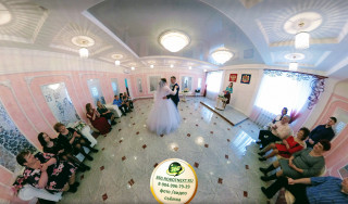
x32 Wedding photography
Wedding photography is a specialty in photography that is primarily focused on the photography of events and activities relating to weddings. It may include other types of portrait photography of the couple before the official wedding day, such as a...

x398 Landscape photography
Landscape photography is an incredibly fun type of photography that requires the photographer to know the basics of photography and painting. Landscape photography has always been and remains a popular and interesting genre. Photos of architecture...

x1159 Virtual 3D Tours
Virtual tour - a way of realistic display of three-dimensional multi-element space on the screen. Elements of a virtual tour, as a rule, are spherical panoramas, interconnected by interactive transition links (hotspots).
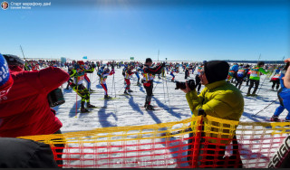
x120 Reporting Photography
Reporting photography is a special type of photography that combines landscape, portrait, domestic and other genres of photography. The main task of reporting shooting is to convey the atmosphere of the event, capture it in faces, emotions, and...

x1409 Airpanorama
Aerial photography - photographing a territory from a certain height from the Earth’s surface using an aerial camera mounted on an atmospheric aircraft, helicopter, airship, etc. or their unmanned analogue in order to obtain, study and present ...

x371 360° Video
360-degree videos, or spherical videos, are video recordings where a view in every direction is recorded at the same time, shot using an omnidirectional camera or a collection of cameras. During playback on normal flat display, the viewer has contro...